The Bald Eagle and Osprey nest registry is a province wide partnership managed by the Wildlife Tree Stewardship (WiTS) program with a goal to support the protection of nest trees covered under Section 34 of the British Columbia Wildlife Act. The WiTS Atlas collects Bald Eagle and Osprey nest records provided by government, industry, conservation/naturalist groups, and the public.
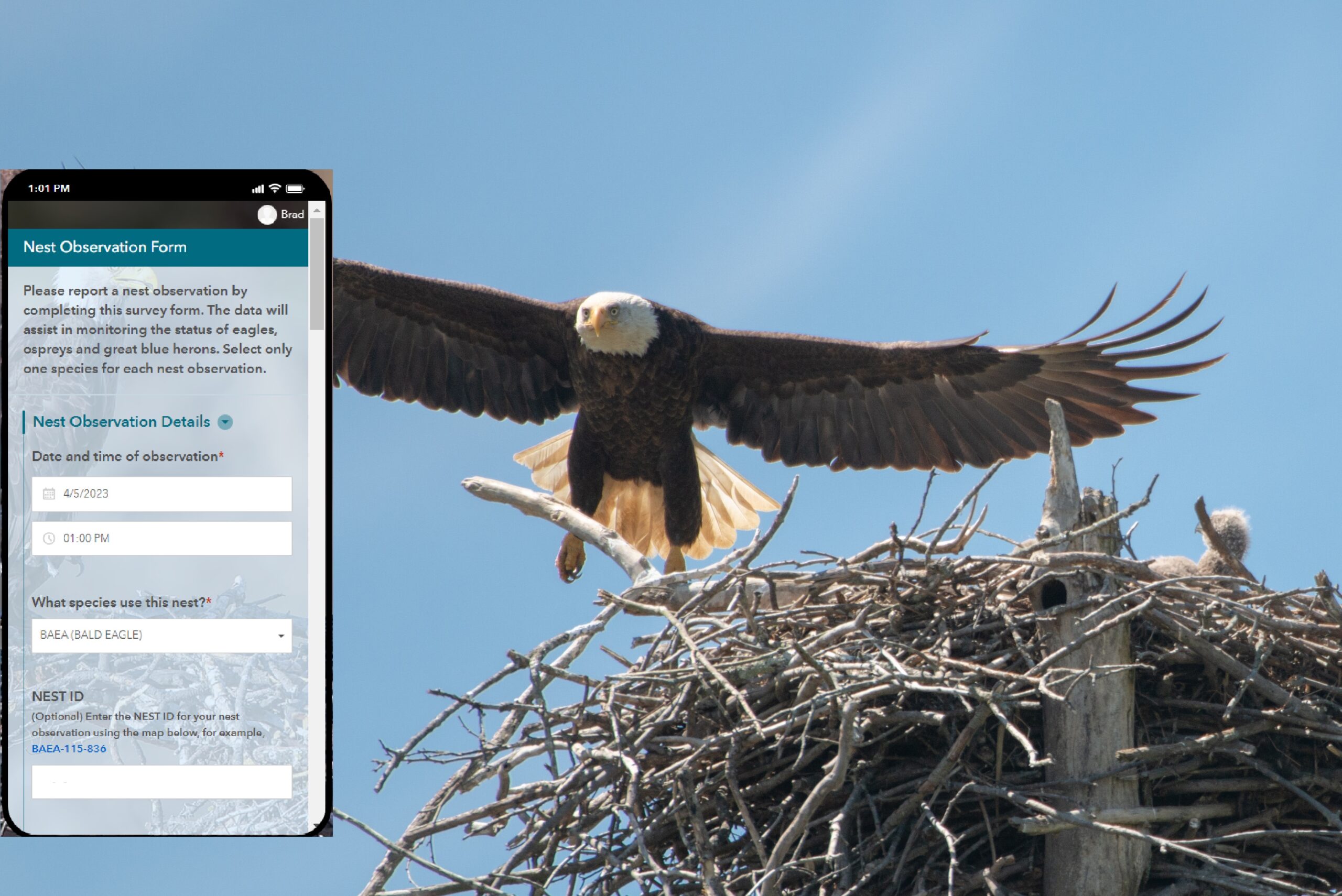
The Community Mapping Network (CMN) has a new publicly available mobile app for collecting and recording nest observations in the field. The WiTS mobile app can be used both online (with an interactive base map) and offline by recording your location coordinates. When on-line, the app will help you find existing nests so that you can update nest activity, the status of the nest tree and other important information. (WiTS Survey123 Instructions). If you have any questions regarding installing or using the WiTS mobile app email Patrick Robinson or Rob Knight (see the contact section below).
The WiTS Atlas grew out of federal and provincial government inventory, mapping, and monitoring programs in the 1990s. WiTS was initially created by CMN in collaboration with Environment Canada, BC Ministry of Environment, BC Hydro, and BC Nature (The Federation of BC Naturalists). Inventory and monitoring of eagle/osprey nest trees is a critical first step in preventing the loss of nest trees and biodiversity during land development. The information available in the WiTS Atlas is published under the following terms and conditions:
1. The Community Mapping Network (CMN) disclaims all responsibility for the accuracy or completeness of this information. It is compiled by the using data derived from a number of sources with varying levels of accuracy.
2. Property owners and lettered professionals on tendered contracts using information in WiTS must verify existing and new nest locations and nest status through independent field work.
3. Distribution of this data is for information purposes only and cannot be used for legal purposes.
4. All data in the WiTS Atlas is provided without warranty of any kind. The user assumes the entire risk as to the quality and performance of the data. No guarantees of accuracy or precision are made and CMN does not accept liability for any damages or misrepresentation caused by inaccuracies in the data, nor is there responsibility assumed to maintain the data in any manner or form or for any period of time.
5. In no event shall CMN or any of the organizations involved with the project, be liable for direct, indirect, incidental, consequential, or special damages of any kind, including, but not limited to, loss of anticipated profits or benefits arising out of use of or reliance on the data.
Once a record is provided to WiTS, the provider has no rights to remove the record or to expect personal recognition or royalties. It is a record of eagle/osprey nesting activity past and present. Nest location and nest status information is updated as frequently as possible based on incoming observations. Because these data are a historical record of important apex predators they are never removed from the atlas. Atlas viewers are advised to read the “User Agreement” for the Community Mapping Network https://www.cmnbc.ca/user-agreement/
WiTS has a policy of not displaying personal or business names. If a personal name is included in a nest observation record, the data manager will edit the record and change a personal name to ‘land-owner’ or ‘local resident’ or some other appropriate descriptor. Business names may be adjusted if the data manager considers it linked with an issue of privacy.
Eagle and Osprey nests may be on private property and nest site records may include directions to the nest location. It is always best to view a nest from a distance. Knowing the location of an nest does not give an observer permission to trespass on private property.
Please reference the 3 documents in the “Atlas Documents” section below for legal requirements and best management practices around raptor nests.
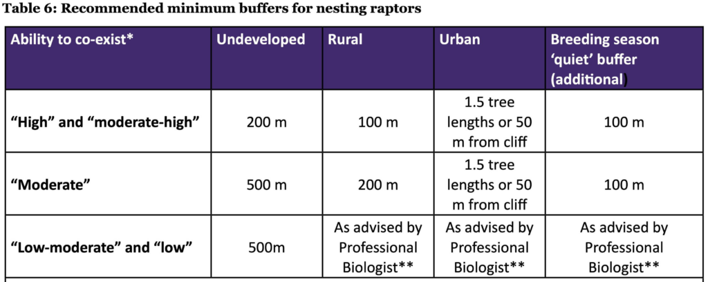
From page 33, Guidelines for Raptor Conservation 2013, Atlas Documents below
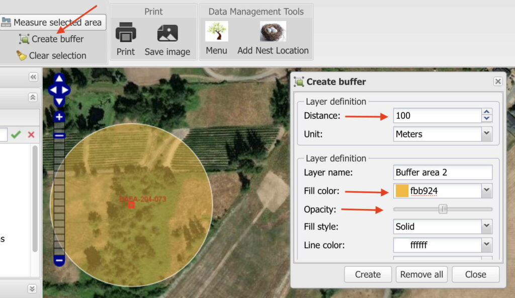
WiTS Atlas users can create temporary buffers for a nest location using the tool indicated by the red arrow (upper left) in the image to the left.
Once a nest point has been selected the buffer diameter can be set using the “Distance” setting as can the “Fill colour” and “Opacity” ( other red arrows).
Nest trees recorded in WiTS do not represent all Bald Eagle and Osprey nest trees – only those documented and submitted to WiTS. Bald Eagle and Osprey nests are protected under Section 34 of the Provincial Wildlife Act regardless of whether or not they are shown on this Atlas. The WiTS program cannot legally warrant the accuracy of the nest tree locations displayed on the Atlas. Lettered professionals on tendered contracts using information in WiTS must verify nest locations and nest status through independent field work and are requested to cite the WiTS information as follows: “Wildlife Tree Stewardship Program (year). Nest Tree Report. The Community Mapping Network. Available: https://www.cmnmaps.ca/wits/ accessed (date)”