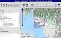
An online atlas was developed for collating best available data about environmental values and features along the Fraser River from Hope to Richmond and coastal foreshore areas from White Rock to Squamish, as relevant to the Lower Mainland Flood Management Strategy.
The purpose is to understand how current and potential future flood infrastructure may adversely or beneficially impact the natural environment. Depending on the breadth, depth and quality of available data, the atlas might help identify environmental features that would need to be addressed in the selection, design, and siting of different flood mitigation projects. It could give early indication of the kinds of environmental issues that would need to be addressed in the regulatory process. It might also help identify candidate sites for protection, conservation, restoration, or compensation related to the Flood Strategy.
Datasets in the atlas have been organized under six main categories, including: base layers; communities; watercourses & wetlands; sensitive ecosystems; fish; and flood. A metadata database has been set up to capture the basic information about each included dataset and to make finding and working with particular instances of data easier.