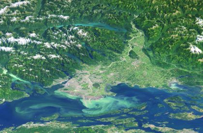
The Fraser Valley Watersheds Atlas is under construction and will be providing many new layers of information in the coming months. The The Fraser Valley Regional District (FVRD) is working with the the Community Mapping Network (CMN), the Fraser Valley Watersheds Coalition (FVWC), and Fisheries and Oceans Canada (DFO) to support the Fraser Valley Watersheds Program. The goal of this Watersheds Program is to help improve the health and sustainability of watersheds throughout the Fraser Valley using watershed planning, enhancement and restoration projects, partnership building, community stewardship, education, and awareness. The four partners, with funding from the Real Estate Foundation of BC, are building a district-wide Watersheds Atlas with up to date environmental information compiled from the member municipalities, senior agencies and many other available sources – a work in progress. Metadata for the Canadian Wildlife Service Fraser Lowland Wetland Loss Mapping 1989-2009 is available in the supporting documents section below.
Contact Organizations
Brad Mason, CMN Director [email protected]
Rob Knight, CMN Director [email protected]
Lance Lilley
Watershed Planner
Fraser Valley Regional District
45950 Cheam Ave. Chilliwack, BC V2P 1N6,
604 702-5006, toll free 1 800 528-0061