Atlas Special Tools: Data Entry
BC Wetlands Atlas
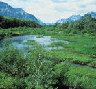
The BC Wetlands Atlas provides a citizen-science based approach to mapping wetlands in British Columbia and is an initiative of the BC Wildlife Federation’s Wetlands Education Program. The Atlas includes...
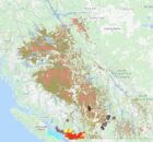
Coquitlam River Watershed Roundtable
The Coquitlam River Watershed Roundtable (CRWR) is a multi-stakeholder and Indigenous knowledge collective within the Lower Coquitlam River Watershed, whose mission is to
- Provide a forum to encourage holistic watershed...
Eelgrass Bed Mapping
Land use changes and developments have led to a loss of natural estuarine habitat in British Columbia. Agriculture, forestry, and dredging for commercial and residential development have all contributed to...
Fisheries Information Summary System Data Entry Tool
The Fisheries Information Summary System (FISS)provides spatially represented summary level fish and fish habitat data for waterbodies throughout British Columbia and the Yukon. The information is in database format and...
Forage Fish Atlas and Data Management System

The ecosystem role of forage fish and the need to protect their critical spawning and rearing habitats requires recognition and public attention. The BC Shore Spawners Alliance is an alliance...
Georgia Strait Alliance
Georgia Strait Alliance is the only citizens' group focused on protecting the marine environment in and around the whole Strait of Georgia – Canada's most at-risk natural environment, and the...
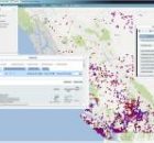
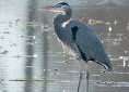
Great Blue Heron (GBHE) Management Team
The web map viewer for this atlas has changed. Be sure to ALWAYS access the atlas using the link provided on this page.
If you use an old bookmark you will...
Invasive Species – Spartina.ca
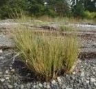
Welcome to the Invasive Species Atlas and home page for the BC Spartina Working Group, a multi-partner initiative in BC and the Pacific Coast to find and control Spartina species.
The...
Private Well Network
The Private Well Network (PWN) is a community-based initiative designed to encourage private well owners to protect their health through regular and affordable testing of well water quality. By sharing...
SHIM (Sensitive Habitat Inventory and Mapping)
As resource development and human populations increase In British Columbia, pressures on all resources and services have accelerated. Rapid growth has often overwhelmed the ability of local planners to manage...