Atlas Type: Community Involvement & Stewardship
BC Wetlands Atlas
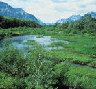
The BC Wetlands Atlas provides a citizen-science based approach to mapping wetlands in British Columbia and is an initiative of the BC Wildlife Federation’s Wetlands Education Program. The Atlas includes...
Comox Valley Project Watershed
Comox Valley Project Watershed Society is a registered non-profit environmental society with Canadian charitable tax status focused on sensitive habitat stewardship. The organization is guided by a...
Coquitlam River Watershed Roundtable
The Coquitlam River Watershed Roundtable (CRWR) is a multi-stakeholder and Indigenous knowledge collective within the Lower Coquitlam River Watershed, whose mission is to
- Provide a forum to encourage holistic watershed...
DISCONNECTED WATERS
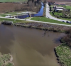
Much of the flood infrastructure in the Fraser Valley that protects homes and farms from flooding, also blocks salmon from accessing waterways that once...
Elk River Alliance
Sensitive Habitat Inventory and Mapping (SHIM) data on Lizard Creek was collected in spring and summer 2011 by the Elk River Alliance (ERA). ERA is a community-based water group, which aims...
Foreshore Integrated Management Planning Atlas
The Columbia Basin Water Hub acknowledges that the data stored on this web atlas is collected from the unceded traditional territories of the Ktunaxa, Lheidli T’enneh, Secwepemc, Sinixt and Syilx...
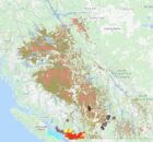
Georgia Basin Habitat Atlas
The Georgia Basin Habitat Atlas will provide up-to-date habitat information to planners, developers, governments, First Nations, community organizations, businesses and the general public. Many individuals and partners are acknowledged for...
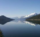
Harrison Salmon Stronghold Restoration and Stewardship Atlas
The Harrison River was designated an International Salmon Stronghold in 2010 by the North American Salmon Stronghold Partnership. The Harrison Salmon Stronghold represents one of the most ecologically significant Pacific salmon...
Rivershed Society of BC Project Rivershed
In 2004, RSBC developed Project Rivershed, to build community capacity, educate the public, and encourage conservation and stewardship of natural resources, especially salmon and water, in riversheds. The program encourages...
SHIM (Sensitive Habitat Inventory and Mapping)
As resource development and human populations increase In British Columbia, pressures on all resources and services have accelerated. Rapid growth has often overwhelmed the ability of local planners to manage...